Bird's eye view of the Clairborne Expressway in Louisiana

Claiborne Expressway, Louisiana: Building a highway through New Orleans’ historically Black neighborhood of Tremé displaced residents and reshaped the community. Today, the economic, environmental, and cultural costs of its development are being reconsidered. William Widmer/The New York Times

Rethinking America’s Highways

The nation’s highways were often built through the heart of urban neighborhoods. People today are coming together to either remove or reimagine the roads.

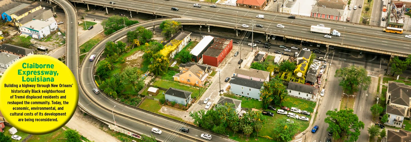
North Claiborne Avenue in Tremé—a historically Black neighborhood in New Orleans, Louisiana—once buzzed with cafes, local businesses, and social clubs that brought the community together on the bustling pedestrian-friendly street.

“It was like the Harlem Renaissance,” says Raynard Sanders, executive director of the Claiborne Avenue History Project. “There was this emergence of Black writers, poets, and all kinds of social activists. . . and the genesis of America’s only art form, which is jazz.”

But in 1968, a new elevated stretch of Interstate 10 tore through the heart of the neighborhood. To make way for the federally funded road, known as the Claiborne Expressway, workers bulldozed 500 homes, 80 businesses, and a large row of giant oak trees. The highway displaced residents and cut neighbors off from one another as the roar of vehicles zooming overhead replaced the music that had long streamed from local jazz halls.

“If you talk to anybody in Tremé,” says salon owner Lynette Boutte, whose family’s roots in the neighborhood trace back generations, “they can tell you about the day the trees came down or when the highway was built.”

For decades, people in Tremé have envisioned a day when the highway might be gone—or at least closed off to traffic—and the neighborhood restored to its former vibrancy.

Tremé is one of many urban neighborhoods that suffered or disappeared entirely as highways began springing up across the U.S. in the late 1950s, often cutting through the heart of low-income and minority communities. But Tremé is also one of many places today where people are coming together to try to remove or reimagine those highways.

North Claiborne Avenue in Tremé is a historically Black neighborhood in New Orleans, Louisiana. It once buzzed with cafes, local businesses, and social clubs. These venues brought the community together on the vibrant, walkable street.

“It was like the Harlem Renaissance,” says Raynard Sanders, executive director of the Claiborne Avenue History Project. “There was this emergence of Black writers, poets, and all kinds of social activists . . . and the genesis of America’s only art form, which is jazz.”

But in 1968, a new elevated stretch of Interstate 10 tore through the heart of the neighborhood. The federally funded road was known as the Claiborne Expressway. To make way for it, workers bulldozed 500 homes, 80 businesses, and a large row of giant oak trees. The highway displaced residents and cut neighbors off from one another. And the roar of vehicles zooming overhead replaced the music that had long streamed from local jazz halls.

“If you talk to anybody in Tremé,” says salon owner Lynette Boutte, whose family’s roots in the neighborhood trace back generations, “they can tell you about the day the trees came down or when the highway was built.”

For decades, people in Tremé have dreamed of a day when the highway might be gone or at least closed off to traffic. They want to see the neighborhood restored to its former glory.

Tremé is one of many urban neighborhoods that suffered or disappeared entirely because of the highway building boom. Highways began springing up across the U.S. in the late 1950s. They often cut through the heart of low-income and minority communities. But Tremé is also one of many places today where people are coming together to try to remove or reimagine those highways.

Tremé before the Claiborne Expressway, 1947 (left); Today the highway cuts through the community (right).

Building the Nation’s Highways

Before the construction of the interstate highway system, most of the nation’s roads remained unpaved or poorly paved, especially outside urban areas. People lived near where they worked. To travel long distances, people often hopped aboard trains. Making a cross-country car trip could take weeks.

But as the automobile became more affordable and car ownership exploded after World War II, making Americans much more mobile, public officials realized that the nation’s road system needed a major upgrade.

President Dwight D. Eisenhower, who led the U.S. during the height of the Cold War, believed an interstate highway system would not only benefit Americans economically but also aid in the nation’s defense: The highways would allow for troop movement and quick evacuation of major cities in case of atomic attack by the Soviet Union.

When Eisenhower signed the Federal-Aid Highway Act of 1956, it authorized the construction of 41,000 miles of roads over the next few decades in what would become the largest public works program in American history.

Before the construction of the interstate highway system, most of the nation’s roads remained unpaved or poorly paved. The roads were especially bad outside of urban areas. People lived near where they worked. To travel long distances, people often hopped aboard trains. Making a cross-country car trip could take weeks.

The automobile became more affordable and car ownership exploded after World War II. That made Americans much more mobile. Public officials soon realized that the nation’s road system needed a major upgrade.

President Dwight D. Eisenhower led the U.S. during the height of the Cold War. He believed an interstate highway system would benefit Americans economically. He also thought it would aid in the nation’s defense by allowing U.S. troops to move throughout the country more easily. And it would be useful to quickly evacuate major cities in case of an atomic attack by the Soviet Union.

Eisenhower signed the Federal-Aid Highway Act of 1956. It called for the construction of 41,000 miles of roads over the next few decades. The project would become the largest public works program in American history.

Planners steered the routes through what they termed ‘blighted’ neighborhoods.

But where would all these new highways go? In a 1954 statement to the President’s Advisory Committee on a National Highway Program, Robert Moses, then an influential urban planner in New York City, said that the new highways “must go right through cities and not around them.”

In many cases, planners and local officials steered the routes of the highways through what they termed “blighted” neighborhoods in the name of “slum clearance.” The American suburbs boomed as highways cropped up, with wealthier residents moving out of cities and now commuting to work by car.

According to Ben Crowther of the Congress for the New Urbanism, an organization that tracks highway removal projects across the country, state and federal officials disproportionally built the highways through communities of color in cities. This happened because their properties had been devalued through redlining, a discriminatory practice in which people were denied loans or mortgages because minority neighborhoods were deemed unworthy of investment by banks and other lenders. This made the cost of land in these areas much cheaper for the government to acquire for construction.

“As a highway builder, you’re looking for the path of least resistance when choosing the path for your highway,” Crowther says. He adds that, politically speaking, communities of color didn’t have powerful allies willing to advocate for them when highway builders developed plans for their routes.

As a result, many highways were built through the heart of urban communities. The U.S. Department of Transportation estimates highway construction displaced members of more than 475,000 households between 1957 and 1977, with more than a million individuals displaced nationwide.

To name a few examples, in Miami, Florida, the expansion of I-95 through the vibrant Black community of Overtown led to the destruction of 87 acres of housing and commercial property. The construction of I-94 through the Black neighborhood of Rondo in St. Paul, Minnesota, resulted in an estimated 600 families displaced and 300 businesses shuttered. And freeway construction through the predominantly Latino neighborhood of Boyle Heights in Los Angeles pushed out at least 10,000 residents in the 1950s and 60s.

In other cities, such as Atlanta, Buffalo, Pittsburgh, and St. Louis, the highways ripped through a path that reinforced already-existing racial divides between Black and White neighborhoods.

“When you use or drive upon a highway, that’s infrastructure that’s built at someone else’s expense,” says Crowther. “Should we be reinvesting in that type of infrastructure if it has winners and losers like that?”

But where would all these new highways go? Robert Moses, then a key urban planner in New York City, had an idea for that. In a 1954 statement to the President’s Advisory Committee on a National Highway Program, he said that the new highways “must go right through cities and not around them.”

Planners and local officials often steered the routes of the highways through what they termed “blighted” neighborhoods in the name of “slum clearance.” As highways cropped up, the American suburbs boomed. Wealthier residents moved out of cities and then commuted to work by car.

The Congress for the New Urbanism tracks highway removal projects across the country. According to Ben Crowther, a representative of the organization, state and federal officials built a larger share of highways through communities of color in cities. This happened because their properties had been devalued through redlining. Through this unjust practice, people were denied loans or mortgages because minority neighborhoods were deemed unworthy of investment by banks and other lenders. This made the cost of land in these areas much cheaper for the government to take over for construction.

“As a highway builder, you’re looking for the path of least resistance when choosing the path for your highway,” Crowther says. He adds that communities of color didn’t have powerful political allies willing to advocate for them when highway builders developed plans for their routes.

As a result, many highways were built through the heart of urban communities. The U.S. Department of Transportation estimates highway construction displaced members of more than 475,000 households between 1957 and 1977. The agency also estimates that more than a million individuals were displaced nationwide.

To name a few examples, in Miami, Florida, the expansion of I-95 through the vibrant Black community of Overtown led to the destruction of 87 acres of housing and commercial property. The construction of I-94 through the Black neighborhood of Rondo in St. Paul, Minnesota, resulted in an estimated 600 families displaced and 300 businesses shuttered. And freeway construction through the predominantly Latino neighborhood of Boyle Heights in Los Angeles pushed out at least 10,000 residents in the 1950s and 60s.

In other cities, such as Atlanta, Buffalo, Pittsburgh, and St. Louis, the highways ripped through a path that reinforced already-existing racial divides between Black and White neighborhoods.

“When you use or drive upon a highway, that’s infrastructure that’s built at someone else’s expense,” says Crowther. “Should we be reinvesting in that type of infrastructure if it has winners and losers like that?”

Reconnecting Cities

Federal and state funds have historically gone to building highways, not removing them. But today, as highways reach the end of their design lifespans, communities face the question of whether to invest in rebuilding, reimagining, or altogether removing these roads.

Today more than 50 local campaigns are underway across the U.S. that advocate either removing or building over highways so they are out of view, according to the Congress for the New Urbanism.

Cities such as Syracuse and Detroit have committed to replacing stretches of highway with more connected and walkable neighborhoods. Others, including New Orleans and Dallas, face pressure from local residents to address issues such as pollution, noise, and safety hazards from the roads.

Many cities are looking to Rochester, New York, as a case study for what highway removal might entail and how it could transform a neighborhood. The Inner Loop used to completely encircle downtown Rochester, cutting it off from the rest of the city. But in an effort to slowly stitch the neighborhood back together, a nearly mile-long section of the sunken road, known locally as “the moat,” was filled in 2017.

Federal and state funds have historically gone to building highways, not removing them. But today, highways are reaching the end of their design lifespans. As that happens, communities face the question of whether to invest in rebuilding, reimagining, or completely removing these roads.

Today, more than 50 local campaigns are underway across the U.S. that advocate either removing or building over highways so they are out of view, according to the Congress for the New Urbanism.

Cities such as Syracuse and Detroit have committed to replacing stretches of highway with more connected and walkable neighborhoods. Others, including New Orleans and Dallas, face pressure from residents to address issues such as pollution, noise, and safety hazards from the roads.

Many cities are looking to Rochester, New York, as a case study for what highway removal might require and how it could transform a neighborhood. The Inner Loop used to completely encircle downtown Rochester. It cut the area off from the rest of the city. But a nearly mile-long section of the sunken road, known locally as “the moat,” was filled in 2017. The move was part of an effort to slowly stitch the neighborhood back together.

Funds have historically gone to building highways, not removing them.

Slowly, the neighborhood is becoming more livable. Several cross-streets that used to be cut off by the highway have been reconnected, making the area more walkable. Where there was once a six-lane chunk of highway, townhouse-style apartments and bike lanes now line the street.   

“Rochester has shown what can be done in terms of reconnecting the city and restoring a sense of place,” says Norman Garrick, a University of Connecticut professor who studies how transportation projects have reshaped American cities. “That’s really the underlying goal of highway removal.”

Slowly, the neighborhood is becoming more livable. Several cross-streets that used to be cut off by the highway have been reconnected. The changes have made the area more walkable. There was once just a six-lane chunk of highway. Now, townhouse-style apartments and bike lanes line the street.

“Rochester has shown what can be done in terms of reconnecting the city and restoring a sense of place,” says Norman Garrick, a University of Connecticut professor who studies how transportation projects have reshaped American cities. “That’s really the underlying goal of highway removal.”

A Community Decision

Support from the federal government is energizing the movement to rethink America’s highways. President Biden’s $1.2 trillion infrastructure plan, signed into law in November 2021, includes $1 billion in funding to “reconnect neighborhoods cut off by historic investments.”

Crowther of the Congress for the New Urbanism says the funding isn’t enough to really change the American highway landscape, but it’s generated more interest in the possibility of removing highways.

“This program does move the needle,” Crowther says.

Highway removal projects are costly. For example, a plan to remove a section of Interstate 81 in Syracuse, New York, and rebuild a portion of Interstate 690 carries a price tag of at least $2 billion—twice the amount approved by Congress for the entire country.

Some residents and officials believe that urban highways, despite the disruptions they may have created when they went up, should remain. They cite the cost of removing or modifying them and the impact on traffic, particularly if no easy alternative routes exist.

Support from the federal government is energizing the movement to rethink America’s highways. President Biden’s $1.2 trillion infrastructure plan was signed into law in November 2021. It includes $1 billion in funding to “reconnect neighborhoods cut off by historic investments.”

Crowther of the Congress for the New Urbanism says the funding isn’t enough to really change the American highway landscape. Still, it’s increased interest in the possibility of removing highways, he adds.

“This program does move the needle,” Crowther says.

Highway removal projects are costly. For example, a plan to remove a section of Interstate 81 in Syracuse, New York, and rebuild part of Interstate 690 carries a price tag of at least $2 billion. That›s twice the amount approved by Congress for the entire country.

Urban highways may have created disruptions when they went up years ago. Still, some residents and officials believe that these highways should remain. They cite the cost of removing or changing them. They also point to the impact on traffic, particularly if no other easy routes exist.

‘Rochester has shown what can be done in terms of reconnnecting the city.’

Others fear that the complete removal of a highway could further damage the surrounding neighborhood—or usher in a wave of gentrification that would push out longtime residents who remained despite the harm to their community inflicted by the original construction.

“There’s the recognition that driving these highways through the communities in the first place was wrong,” says Chris McCahill, managing director of State Smart Transportation Initiative, a transportation think tank based at the University of Wisconsin-Madison. “And so now the question becomes, what to do about it now?”

When Biden first announced the infrastructure plan, he specifically pointed to New Orleans’ Claiborne Expressway as an example of how transportation projects of the past severed neighborhoods and helped drive racial inequalities. Sanders of the Claiborne Avenue History Project says the bill has generated renewed interest in “helping to cure this wrong that was done.”

While in the past, the people of Tremé had no say when the bulldozers came into town and started wiping out the houses and trees, today, members of the community are coming together to voice concerns about the highway and discuss whether to keep it, tear it down, or build something new underneath.

This time around, says Sanders, “it’s the community’s decision.”

Others fear that the complete removal of a highway could further damage the surrounding neighborhood. They also fear that it might usher in a wave of gentrification that would push out longtime residents who remained despite the harm to their community inflicted by the original construction.

“There’s the recognition that driving these highways through the communities in the first place was wrong,” says Chris McCahill, managing director of State Smart Transportation Initiative, a transportation think tank based at the University of Wisconsin-Madison. “And so now the question becomes, what to do about it now?”

When Biden first announced the infrastructure plan, he specifically pointed to New Orleans’ Claiborne Expressway as an example of how transportation projects of the past severed neighborhoods and helped drive racial inequalities. Sanders of the Claiborne Avenue History Project says the bill has led to renewed interest in “helping to cure this wrong that was done.”

In the past, the people of Tremé had no say when the bulldozers came into town and started wiping out the houses and trees. Today, members of the community are coming together to voice concerns about the highway. And they’re discussing whether to keep it, tear it down, or build something new underneath.

This time around, says Sanders, “it’s the community’s decision.”

With reporting from Audra D. S. Burch, Nadja Popovich, Josh Williams, and Denise Lu of The New York Times.

With reporting from Audra D. S. Burch, Nadja Popovich, Josh Williams, and Denise Lu of The New York Times.

By the Numbers

The Federal-Aid Highway Act of 1956

Bettmann Archive/Getty Images (Eisenhower); ©Bill Bachmann/Alamy Stock Photo (sign)

President Eisenhower (above) championed the act.


41,000

MILES of highways authorized

MILES of highways authorized

$25 billion

AMOUNT of money the federal government allocated to build the interstate highway system

AMOUNT of money the federal government allocated to build the interstate highway system

90%

SHARE of cost the federal government paid for highway construction

SHARE of cost the federal government paid for highway construction

1957–69

SPAN of years during which states received federal funding for highway construction

SPAN of years during which states received federal funding for highway construction

SOURCE: U.S. House of Representatives

SOURCE: U.S. House of Representatives

William Widmer/The New York Times

Amy Stelly wants to return Claiborne Avenue to “its former glory.”

Living With the Highway

Longtime resident Amy Stelly, on life in Tremé before and after the Claiborne Expressway went in

Before the highway, Claiborne Avenue used to really serve the Black community. During Jim Crow, Black people in New Orleans weren’t allowed to shop downtown, so Claiborne became their downtown. There were doctors, dentists, lawyers, insurance agents, and funeral homes.

I was maybe between 6 and 8 when the work on the highway began. The community went from really thriving to being totally disinvested. Today we have gun violence and a lot of opioid use here because people congregate under the highway’s ramp. We still have a very vibrant culture, but we also have a lot to contend with.

I live in the house I grew up in a block and a half from the highway, and I have to scrub the particulate matter off our house, so you can imagine what we’re breathing in—it’s bad. The noise pollution is really bad too, and it’s horrible on weekends. And if we have torrential rains, the water just shoots off the highways in sheets, and the drainage system doesn’t work, so all that dirty water is going into the neighborhood. It’s been a challenge to live with, and I don’t think we deserve all of that.

I hope we’ll be able to return Claiborne to its former glory. The community would love to see the median restored as a beautiful parkway and economic development activities that restore Claiborne as a Black Wall Street. It will take time, but I am confident we can do it.

as told to Rebecca Katzman

The Inner Loop: Rochester, New York

City of Rochester via The New York Times

BEFORE REMOVAL

The sunken Inner Loop in Rochester, New York, completely encircles the downtown area, cutting it off from the rest of the city.

The sunken Inner Loop in Rochester, New York, completely encircles the downtown area, cutting it off from the rest of the city.

Mustafa Hussain/The New York Times

AFTER REMOVAL

Today, new bike lanes and apartments stand where a section of the Inner Loop once did in an effort to begin reconnecting the city.

Today, new bike lanes and apartments stand where a section of the Inner Loop once did in an effort to begin reconnecting the city.

Skills Sheets (6)
Skills Sheets (6)
Skills Sheets (6)
Skills Sheets (6)
Skills Sheets (6)
Skills Sheets (6)
Lesson Plan (1)
Leveled Articles (1)
Text-to-Speech