

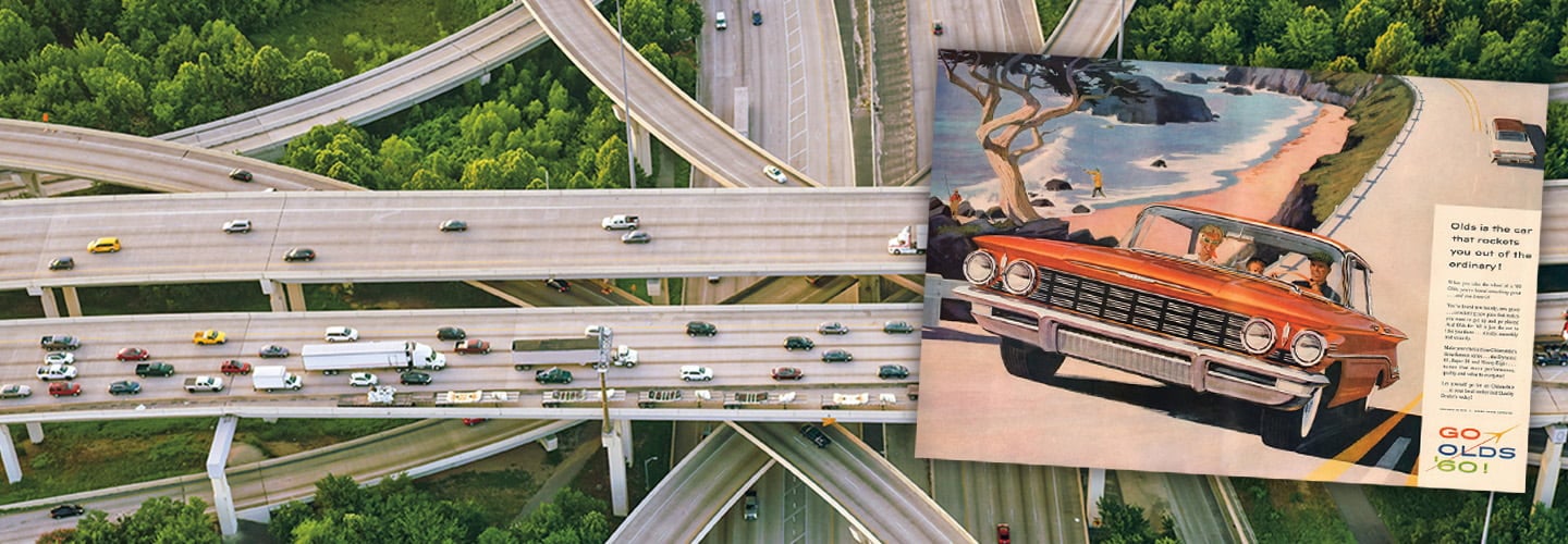

Composite image of an aerial view of a highway interchange with a vintage Go Olds 60 car ad overlaid

Ads like this one (above, right) romanticized the highway as a symbol of American freedom. simonkr/Getty Images (highway); Classic-Ads/Alamy Stock Photo (ad)

Standards

How Highways Changed America

Seventy years ago, the Interstate Highway System was created. It reshaped the nation in ways still felt today.

More than three decades before he became president of the United States, Dwight D. Eisenhower went on a cross-country road trip. The year was 1919, and such journeys were uncommon. Cars were just starting to become affordable for the average family, and many of the nation’s roads remained unpaved.

Eisenhower, then a 28-year-old lieutenant colonel in the Army, had joined a military convoy from Washington, D.C., to San Francisco. The purpose of the trip was to see how quickly the military could move across the country for national defense and to draw public attention to the need for good roads. The trip took more than two months.

In 1919, Dwight D. Eisenhower went on a cross-country road trip. The journey was unusual. Cars were just starting to become affordable for the average family. Many of the nation’s roads remained unpaved.

Eisenhower was a 28-year-old lieutenant colonel in the Army. It was more than 30 years before he would become president. He had joined a military convoy from Washington, D.C. to San Francisco. The military wanted to see how quickly it could move across the country for national defense. They also hoped to draw public attention to the need for good roads. The trip took more than two months.

People were suddenly a lot less constrained by geography.

In Nebraska, “two days were lost in [the] western part of this state due to bad, sandy roads,” Eisenhower wrote in a report on the journey. Between Utah and Nevada, “the road is one succession of dust, ruts, pits, and holes.”

In the ensuing three decades, the federal government began planning a network of highways that would connect major U.S. cities and allow for high-speed driving on paved roads. But it wasn’t until Eisenhower’s presidency that the government secured the funding necessary for a comprehensive cross-country highway system. On June 29, 1956, 70 years ago this summer, President Eisenhower signed the Federal-Aid Highway Act, authorizing the construction of 41,000 miles of highway across the nation.

Completed in 1992 at a cost of more than $100 billion, the Interstate Highway System profoundly shaped America’s geography, economy, and culture in ways still felt today.

“It bound the country together,” says Earl Swift, author of The Big Roads, a history of the system. “It’s one of the best investments that the federal government’s ever made.”

In Nebraska, “two days were lost in [the] western part of this state due to bad, sandy roads,” Eisenhower wrote in a report on the journey. Between Utah and Nevada, “the road is one succession of dust, ruts, pits, and holes.”

In the next 30 years, the federal government began planning a network of highways that would connect major U.S. cities. The paved roads would allow for high-speed driving. But it wasn’t until Eisenhower’s presidency that the government secured the funding necessary for a comprehensive
cross-country highway system. On June 29, 1956, 70 years ago this summer, President Eisenhower signed the Federal-Aid Highway Act. It authorized the construction of 41,000 miles of highway across the nation.

The Interstate Highway System was completed in 1992. It cost more than $100 billion and profoundly shaped America’s geography, economy, and culture.

“It bound the country together,” says Earl Swift, author of The Big Roads, a history of the system. “It’s one of the best investments that the federal government’s ever made.”

ClassicStock/Alamy Stock Photo

Suburban life became the American Dream in the 1950s.

A Unified System

In the beginning of the 20th century, Americans traveled long distances primarily by train (see “Moving America,” below). But by 1929, about 60 percent of U.S. households had a car. And a growing number of car owners yearned to see the country at large.

To travel any distance beyond their own towns, Americans could use the numbered highway system, established by the mid-1920s. The numbered highways unified the patchwork of roads—previously known as auto trails—that crisscrossed the country and provided an early blueprint for a national highway network. Many were two-lane roads without safety features such as shoulders or guardrails, and as a result were congested and dangerous. The rate of traffic deaths in 1926 was more than 10 times higher than it is today.

In the 1930s, President Franklin Delano Roosevelt began exploring the construction of an interstate highway system that would allow for long-distance, higher-speed driving by eliminating intersections and stoplights. He saw road building as a way to put Americans back to work during the Great Depression (1929-39). He also wanted the U.S. to catch up to Germany’s autobahn, a network of government-funded high-speed superhighways. He directed the Bureau of Public Roads, a federal agency, to study the feasibility of a similar system. But the nation’s resources were tied up fighting World War II (1939-45), making construction progress difficult.

When President Eisenhower came into office in 1953, he made funding the interstate highway system a priority. His primary goals were to make American roads safer and less congested and to facilitate interstate commerce. He also saw the highway system as a way to evacuate cities in the event of a nuclear attack.

“The uniting forces of our communication and transportation systems are dynamic elements in the very name we bear—United States,” he wrote in a 1955 message to Congress. “Without them, we would be a mere alliance of many separate parts.”

The 1956 Federal-Aid Highway Act outlined funding for the massive project. The federal government would cover 90 percent through taxes on gasoline and tires, while states would be responsible for acquiring the land and raising local taxes to cover the other 10 percent. The legislation also established national standards for the design of the interstates, including a minimum of two lanes in each direction.

In the beginning of the 20th century, Americans traveled long distances primarily by train (see “Moving America,” below). But by 1929, about 60 percent of U.S. households had a car. Car owners yearned to see the country at large.

A numbered highway system was established by the mid-1920s. The numbered highways unified the patchwork of roads—previously known as auto trails—that crisscrossed the country. It provided an early blueprint for a national highway network. Americans could use the roads to travel beyond their own towns, but many were two-lane roads without safety features such as shoulders or guardrails. This made the roads congested and dangerous. The rate of traffic deaths in 1926 was more than 10 times higher than it is today.

In the 1930s, President Franklin Delano Roosevelt began exploring the construction of an interstate highway system. It would allow long-distance, higher-speed driving by eliminating intersections and stoplights. He saw road building as a way to put Americans back to work during the Great Depression (1929-39). He also wanted the U.S. to catch up to Germany’s autobahn, a network of government-funded high-speed superhighways. He directed the Bureau of Public Roads, a federal agency, to study the feasibility of a similar system. But the nation’s resources were tied up fighting World War II (1939-45), and it was difficult to make progress on the construction.

When President Eisenhower came into office in 1953, he made funding the interstate highway system a priority. He wanted to make American roads safer and less congested. Another goal was to facilitate interstate commerce. He also saw the highway system as a way to evacuate cities in the event of a nuclear attack.

“The uniting forces of our communication and transportation systems are dynamic elements in the very name we bear—United States,” he wrote in a 1955 message to Congress. “Without them, we would be a mere alliance of many separate parts.”

The 1956 Federal-Aid Highway Act outlined funding for the massive project. The federal government would cover 90 percent through taxes on gasoline and tires. States would be responsible for acquiring the land and raising local taxes to cover the other 10 percent. The legislation also established national standards for the design of interstates, including a minimum of two lanes in each direction.

Suburban Growth

The interstates built in the following decades, marked by distinctive crest-shaped blue-and-red signs, had profound effects on an America in which people were suddenly a lot less constrained by geography.

One of the biggest changes was the explosion of the suburbs—and the decline of the cities they surrounded. The interstate enabled millions of residents of cities like Detroit, Baltimore, and New York to escape to greener pastures and commute to work from the suburbs. Many were World War II veterans using low-interest mortgages from the G.I. Bill to buy their first homes in suburbs that seemed to sprout overnight in what had been wheat and potato fields. The American Dream became a house with a yard and a two-car garage. However, that dream was largely reserved for White Americans. Discriminatory bank lending practices and housing policies kept it out of reach for many Black Americans.

Throughout the 1960s and ’70s, suburban life became more separate from that of the city. Suburbs erected shopping centers and huge malls, as department stores—once found only in cities—followed their customers to their new homes. The migration of businesses further drained economic activity from struggling downtowns.

“The growth of these auto-dependent suburbs disconnects your retail environment from your downtown,” says Kathleen Franz, a curator at the Smithsonian National Museum of American History. “So people have to drive more.”

The interstates built in the following decades were marked by distinctive crest-shaped blue-and-red signs. People were suddenly a lot less constrained by geography, and America began to change.

There was an explosion of the suburbs and a decline of the cities they surrounded. The interstate enabled millions of residents of cities like Detroit, Baltimore, and New York to escape to greener pastures and commute to work from the suburbs. Many were World War II veterans using low-interest mortgages from the G.I. Bill to buy their first homes. Suburbs seemed to sprout overnight in what had been wheat and potato fields. The American Dream became a house with a yard and a two-car garage. However, that dream was largely reserved for White Americans. Discriminatory bank lending practices and housing policies kept it out of reach for many Black Americans.

Throughout the 1960s and ’70s, suburban life became more separate from that of the city. Suburbs built shopping centers and huge malls, so department stores—once found only in cities—followed their customers to their new homes. The migration of businesses caused a further strain on struggling downtowns.

“The growth of these auto-dependent suburbs disconnects your retail environment from your downtown,” says Kathleen Franz, a curator at the Smithsonian National Museum of American History. “So people have to drive more.”

One of the biggest changes was the explosion of the suburbs.

By making cross-country travel easier and safer, the Interstate Highway System also made vacations readily accessible to more Americans. Entire new industries developed to serve commuters and long-distance travelers, including chain motels such as Howard Johnson’s and Holiday Inn, and fast-food restaurants such as McDonald’s.

While the Interstate Highway System led to the growth of the suburbs, it also hollowed out many urban communities. As local transportation planners decided where the highway should go in their states, they aligned their efforts with the urban renewal movement. Urban renewal was a federal government program to revitalize inner cities by demolishing old housing and replacing it with modern public housing or new businesses. Many urban planners referred to this process as “slum clearance.”

By the 1950s, most of those inner-city areas were predominantly Black. The federal government policy of redlining, which rated urban areas for investment, had deemed most Black neighborhoods unsuitable for government lending programs. That meant that the land in these neighborhoods was also the cheapest to acquire for highway construction.

“Lots of neighborhoods were just demolished,” says Mark Rose, a professor of history at Florida Atlantic University.

By making cross-country travel easier and safer, the Interstate Highway System also made vacations readily accessible to more Americans. Entire new industries developed to serve commuters and long-distance travelers. Chain motels such as Howard Johnson’s and Holiday Inn, and fast-food restaurants such as McDonald’s spread.

While the Interstate Highway System led to the growth of the suburbs, it also created many urban communities. As local transportation planners decided where the highway should go in their states, they aligned their efforts with the urban renewal movement. Urban renewal was a federal government program to revitalize inner cities by demolishing old housing. It was replaced with modern public housing or new businesses. Many urban planners referred to this process as “slum clearance.”

By the 1950s, most of those inner-city areas were predominantly Black. The federal government policy of redlining, which rated urban areas for investment, had deemed most Black neighborhoods unsuitable for government lending programs. The land in these neighborhoods was the cheapest to acquire for highway construction.

“Lots of neighborhoods were just demolished,” says Mark Rose, a professor of history at Florida Atlantic University.

Afro American Newspapers/Gado/Getty Images

Protesters demonstrate against freeway construction in Washington, D.C., 1968.

Freeway Revolts

In cities across the country, from New York to Minneapolis to Los Angeles, predominantly Black and Hispanic neighborhoods were razed to make way for the interstate, forcing residents to move. Most couldn’t move to the suburbs because of discriminatory practices such as real estate covenants—clauses in deeds that said properties couldn’t be rented or sold to people of color.

Many were “forced to live in the shadow of the highway” amid its pollution, says Deborah Archer, a professor at New York University School of Law. “Churches, schools, Black- and Hispanic-owned businesses . . . were lost.” In cities such as Birmingham, Alabama, and Dallas, Texas, highway construction was used to physically enforce the segregation of predominantly Black and Hispanic neighborhoods.

In cities across the country, from New York to Minneapolis to Los Angeles, predominantly Black and Hispanic neighborhoods were cleared to make way for the interstate. Residents had to move, but most couldn’t move to the suburbs because of discriminatory practices. Real estate covenants—clauses in deeds—prevented the properties from being rented or sold to people of color.

Many were “forced to live in the shadow of the highway” amid its pollution, says Deborah Archer, a professor at New York University School of Law. “Churches, schools, Black- and Hispanic-owned businesses . . . were lost.” In cities such as Birmingham, Alabama, and Dallas, Texas, highway construction was used to physically enforce the segregation of predominantly Black and Hispanic neighborhoods.

‘Lots of neighborhoods were just demolished.’   

Communities across the country fought against interstate construction in what became known as the Freeway Revolts. The protests began in 1959 in San Francisco, where activists successfully forced the city to cancel a planned freeway extension that would cut through Golden Gate Park. In Washington, D.C., protesters stopped several interstate segments that would have cut through residential neighborhoods and popularized the rallying cry “White men’s roads through Black men’s homes.”

Despite such protests, the construction of the Interstate Highway System ultimately displaced more than 1 million people nationwide, according to the Department of Transportation.

“We wouldn’t be the country we are today without the connectivity the highway system provides,” says Archer. “But it also has the legacy of Black and Brown communities that have been disconnected and blocked from access to economic opportunity.”

Communities across the country fought against interstate construction. Freeway Revolts began in 1959 in San Francisco. Protesters successfully forced the city to cancel a planned freeway extension that would cut through Golden Gate Park. In Washington, D.C., protesters stopped several interstate segments that would have cut through residential neighborhoods. They popularized the rallying cry “White men’s roads through Black men’s homes.”

Despite such protests, the construction of the Interstate Highway System ultimately displaced more than 1 million people nationwide, according to the Department of Transportation.

“We wouldn’t be the country we are today without the connectivity the highway system provides,” says Archer. “But it also has the legacy of Black and Brown communities that have been disconnected and blocked from access to economic opportunity.”

Andrew Haliburton/Alamy Stock Photo

Reimagining highways: In Boston, the Rose Kennedy Greenway replaced the elevated I-93 highway that cut through the city’s downtown.

Highway Nation

Today the Interstate Highway System spans nearly 49,000 miles, connecting Seattle to Boston and San Francisco to Teaneck, New Jersey. Constituting just 1 percent of the nation’s total highways, it carries 25 percent of U.S. traffic. It remains critical to our economy, allowing millions of tons of goods to be transported each day. Traveling on the interstate highway is twice as safe as driving on other roads, according to the Federal Highway Administration.

But the heavily trafficked system is in sore need of maintenance and modernization, experts say. A congressionally commissioned 2019 report by the Transportation Research Board found that 47 percent of interstate highways are considered congested during peak hours, and that more than a quarter of bridges in the system need repair or replacement. The federal government is currently spending billions of dollars on highway megaprojects to add lanes and replace bridges in several states.

In recent decades, many cities across the country have countered some of the interstate’s harmful effects by removing or relocating portions of it. The largest of these projects, completed in Boston in 2007, routed a six-lane portion of I-93 underground. Engineers replaced the highway, which had separated the city’s downtown from its waterfront, with the 17-acre Rose Kennedy Greenway. Now instead of dangerous intersections, residents have access to a 1.5-mile plant-lined pedestrian path.   

What will the next 70 years hold for America’s interstates?

The highway system, said Francis C. Turner, a former head of the Federal Highway Administration, “will never be finished because America will never be finished.”

Today the Interstate Highway System spans nearly 49,000 miles. It connects Seattle to Boston and San Francisco to Teaneck, New Jersey. Constituting just 1 percent of the nation’s total highways, it carries 25 percent of U.S. traffic. It remains critical to our economy. Millions of tons of goods are transported each day. Traveling on the interstate highway is twice as safe as driving on other roads, according to the Federal Highway Administration.

But the heavily trafficked system is in sore need of maintenance and modernization, experts say. A congressionally commissioned 2019 report by the Transportation Research Board found that 47 percent of interstate highways are considered congested during peak hours. More than a quarter of bridges in the system need repair or replacement. The federal government is currently spending billions of dollars on highway megaprojects to add lanes and replace bridges in several states.

In recent decades, many cities across the country have countered some of the interstate’s harmful effects by removing or relocating portions of it. The largest of these projects was in Boston. Completed in 2007, the project routed a six-lane portion of I-93 underground. The highway had separated the city’s downtown from its waterfront. Engineers replaced it with the 17-acre Rose Kennedy Greenway. Now instead of dangerous intersections, residents have access to a 1.5-mile plant-lined pedestrian path.   

What will the next 70 years hold for America’s interstates?

The highway system, said Francis C. Turner, a former head of the Federal Highway Administration, “will never be finished because America will never be finished.”

With reporting by Sam Roberts of The New York Times.

With reporting by Sam Roberts of The New York Times.

MOVING AMERICA

U.S. Transportation Milestones

1807: Steamships

Shutterstock.com

Commercial steamship service begins on New York’s Hudson River. The ships’ wood-burning engines allow the movement of people and goods regardless of currents and wind.

Commercial steamship service begins on New York’s Hudson River. The ships’ wood-burning engines allow the movement of people and goods regardless of currents and wind.

1869: Transcontinental Railroad  

Shutterstock.com

The nation’s first cross-country railroad line is finished. It cuts the length of a trip between New York and San Francisco from months to about a week.

The nation’s first cross-country railroad line is finished. It cuts the length of a trip between New York and San Francisco from months to about a week.

1953: Air Travel

Shutterstock.com

The first nonstop transcontinental passenger flight travels from Los Angeles to New York City.

The first nonstop transcontinental passenger flight travels from Los Angeles to New York City.

2000: High-Speed Rail

Shutterstock.com

Amtrak launches its high-speed rail service, Acela, between Washington, D.C., and Boston.

Amtrak launches its high-speed rail service, Acela, between Washington, D.C., and Boston.

TODAY: Robotaxis

Shutterstock.com

Since 2020, private companies including Waymo, Tesla, and Uber have been rolling out driverless taxi service in dozens of cities across the country.

Since 2020, private companies including Waymo, Tesla, and Uber have been rolling out driverless taxi service in dozens of cities across the country.

On the Road

The U.S. Interstate System by the numbers

80 mph

FASTEST SPEED LIMIT on a U.S. interstate, found in rural areas of several Western states, including Idaho, Montana, and Wyoming.

FASTEST SPEED LIMIT on a U.S. interstate, found in rural areas of several Western states, including Idaho, Montana, and Wyoming.

405,000

Shutterstock.com

AVERAGE NUMBER of vehicles that drive daily on I-75 (right) in Atlanta, the most traveled section of any road in the U.S.

AVERAGE NUMBER of vehicles that drive daily on I-75 (right) in Atlanta, the most traveled section of any road in the U.S.

15

NUMBER of states crossed by I-95, the most of any interstate in the system.

NUMBER of states crossed by I-95, the most of any interstate in the system.

SOURCES: Federal Highway Administration; Insurance Institute For Highway Safety

SOURCES: Federal Highway Administration; Insurance Institute For Highway Safety

Skills Sheets (3)
Skills Sheets (3)
Skills Sheets (3)
Lesson Plan (1)
Leveled Articles (1)
Text-to-Speech